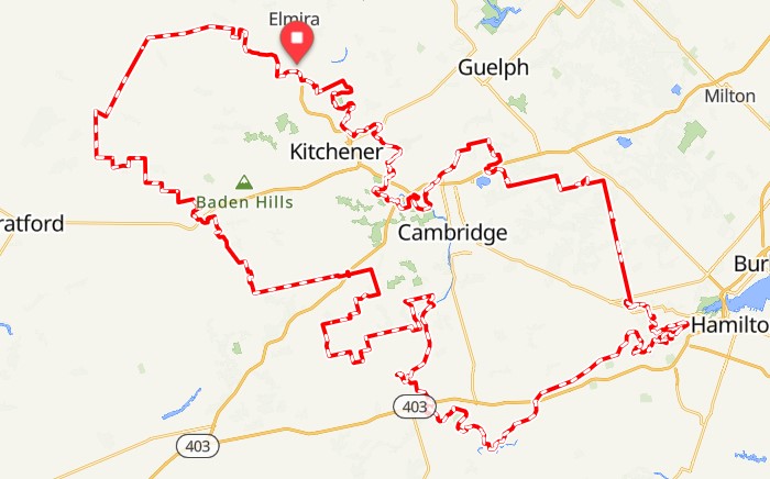
The GNR Bikepacking Route
.
The trail-heavy Grand Nith Ramble (GNR) was born to not only to offer an extension to the BT 700 route, but to also showcase two of southeastern Ontario’s most alluring rivers – the Grand and Nith. And just maybe the trail will begin in the jungle and take you to the mythic Paradise City. But most certainly, a river runs through it.
Start your journey in the village of St. Jacob’s, located in the heart of Mennonite country, where it doesn’t take long to ditch pavement for forested trail. From here, riders will wend their way south to escarpment country and then back north along punchy gravel, sinuous trail, well maintained rail trail and undulating roads with a surfeit of bucolic views. It is not designed to be the easiest, most direct route possible, but one that inspires a sense of two-wheel adventure. The scenery won't disappoint, and either will the welcoming hospitality.
Even though the route runs into some fairly big urban centres it never really feels like you are too far removed from quiet countryside and natural ecosystems that will appeal to any bikepacker. A far more diverse appeal than just fields of corn.
By the Numbers
Distance: 370 Kilometres
Total Ascent: 3,000 metres
Unpaved/Paved: 75%/25%
Non-pavement surfaces are in the form of gravel roads, doubletrack, singletrack and rail trail.
Highlights
You’ll be amazed by the volume of singletrack, doubletrack and rail trail riding on the route while never venturing too far from a hot meal and cold beer. Railing along some sections of sweet trail will put you up close and personal with the mighty Grand river - a designated heritage river that has been home to indigenous people for more than 10,000 years.
Picture-worthy river views seemingly await you at ever bend in the trail.
Ride deep into the thickly forested, waterfall-laden Dundas Conservation Area. It’s so vast some riders have yet to come out. Hands down one of the prettiest sections of the route.
Puslinch, Little Track and Sudden Track offer up plenty of opportunity for shinrin-yoku on two wheels.
Score bragging rights by conquering the notorious Lafarge trail.
A chance to ride along a handful of historic steel truss bridges spanning the Nith River - several of which are closed to vehicular traffic. You’ll be tempted to spend a night with the howling coyotes.
Big country views are the order of the day on the lonely country gravel roads.
Avail yourself of one (or many!) of the local breweries that dot the route. A well deserved pint is never far away.
From kingfishers to indigo buntings, there is no shortage of birdlife along the waterways. Can you spot the GNR heron?
Small independently owned eateries await riders to help fuel long days in the saddle. The pastéis de nata from Lucio’s is highly recommended rocket fuel.
Close-tied communities like Ayr, New Hamburg and Linwood offer up all the small town charm you can handle.
Cozy riding along the well-developed G2G and Hamilton Brantford rail trails.
Navigation
There are TWO route files you should have downloaded for the GNR. It is advised that you have some practice using your navigation devices before heading out on the GNR especially if you haven’t previously navigated trail systems. GPS navigation is a must. It would be very hard to follow this route with a paper map. The route can be updated or modified at any time, so it's best to review the route in advance for trip planning purposes but only download these files shortly before your ride so you have the most up-to-date route.
Please DO NOT use old route files floating around Ride with GPS from other riders or files you may have downloaded a long time ago. The links here are the current route you should be using.
1) This is a bare-bones file for navigation because devices like Garmins and Wahoos do not handle large files well and will not show Points of Interest.
https://ridewithgps.com/routes/43454327
If downloading a .gpx file DO NOT click on Reduce to 500 Points. This will result if poor navigation. Here is some additional information on downloading the route to your navigation device.
You can also use this file to navigate with on your mobile phone using the Ride with Gps app. For non BT 700 club members offline navigation is only available for those with a paid membership. It's best to have the file with the Points of Interest on your phone.
Here is an excellent tutorial on how to use routes using Ride with GPS and other navigation devices: https://ridewithgps.com/journal/7347-customize-your-bikepacking-com-adventure
Some GPS navigation devices, including the Garmin eTrex, have a track-point limit to the .gpx files they can store. And some devices just don't function optimally when working with a lengthy route. For this reason, breaking up the route file into smaller segments might be necessary. Here is a tutorial on how to break up a route into two or more segments. Note: you'll need to save the route to your route library on Ride with GPS before splitting the route into shorter segments.
If needed, here is a tutorial from Ride with GPS on how to import a route that you have saved in your Ride with GPS route library from the mobile app directly to your Garmin or Wahoo using bluetooth.
2) This is a larger file that includes numerous Points Of Interest (POIs) and can be used for planning your trip both beforehand and during your ride: https://ridewithgps.com/routes/30874383
This route file should be downloaded using the Ride with GPS mobile app (https://ridewithgps.com/help/mobile/). To download, click on the route link while using your mobile device and it should pop up in the app, then click download. All the Points of Interest including locations for food services, bike shops, hotels and camping areas will remain visible. Tap on a POI and the additional information will be displayed such as the opening hours for food outlets. Zoom in on a particular area of the route as some POI’s overlap and many of them are not visible when zoomed out.
Note: In the route file maps below you'll see a "send to device" tab on the top. Clicking this while using your mobile device will let you directly upload the route to the Ride with GPS app on your mobile device. More info on this process here.
FREE Off-line Navigation with your phone: If you become a BT 700 Bikepacking Club Member (no cost) you'll be able to download the route using the Ride with GPS app and access it's navigational features including voice prompts. Normally, this is only available for Premium Account subscribers. All you will need is a free Ride with GPS account.
Anyone with a free or paid Ride with GPS account who clicks this link will be added to the club and automatically approved. Just click View in the Route Library and it will open up a route file that can be downloaded. Here is some more info about the benefits of being a club member.
NOTE: When downloading the file for Offline navigation, it can take a long time. On the app, under the Offline Tab in your Library, you should see a NAVIGATE symbol.
Here is a good article about the pros and cons of using a smartphone to navigate with the Ride with GPS app.
When navigating with the mobile Ride with GPS app, it’s best not to rely solely on the voice prompts as sometimes they can steer you in the wrong direction. The line on the map remains the best navigation tool.
Using both a navigation device like Garmin and the Ride with GPS mobile app when riding a route can offer a nice safety net. If one is not going well, then you have a second option for navigating.
If running the Ride with GPS mobile app as you ride you can enable Live Logging so friends and family can follow your journey in live time. This is available for Basic and Premium members.
If you run into issues downloading these files onto any of your devices let me know and I can try to provide assistance.
Route Notes
Note: There are a few sections on the route file colored in blue. These illustrate the more challenging trails that riders can choose to ride or not. These are great riding for those who like to spice up their bikepacking with singletrack. The master route file with Points of Interest suggest alternatives to these sections.
Note: The lovely old bridge over the Nith River before entering the town of Ayr at the 241km mark of the route now has about a 4 foot farm-style fence on either end. It can be climbed over, but this is easier with two or more people to help with lifting bikes. Some riders report being able to slide their bikes through the openings in the metal gate. If you are unable to take this option, at the 239.5km mark of the route you go east on Brant Waterloo Rd to Swan Street. Take Swan Street north into town.
Note: If conditions have been wet and humid some of the trails along the Grand River can become weedy and jungle-like. It's always best to do a tick check after immerging from any bushwalking and if you are sensitive to any weeds try to wash your exposed skin with hot, soapy water as soon as possible.
Trip Start: The designated start and end point is the red tractor at Ecocafe in the village of St. Jacob’s, but the route can be started at any point that best suits a rider. The route rides best in a clockwise direction. If needed, riders can obtain a room discount at the Holiday Inn in St. Jacob's by using the link on the BT Friends page.
Parking: If needed, riders can obtain a free multi-day parking permit in the start/finish town of St. Jacob's. Contact me if you require this.
Difficulty: The GNR is not as demanding as the BT 700 in terms of ruggedness and elevation gain. But that doesn't mean it should be taken too lightly even if not 'epic' in the true sense of the word. There are enough testing inclines and other trail nuances in the route to keep riders from simply just cruising along the river. Even experienced gravel riders and bikepackers will find their challenges on the route. It can be rated as an intermediate ride, but also a good introduction to bikepacking for those going at a more casual pace. With the exception of a few short sections, the trails used for the GNR are not especially technical and don’t require expert mountain bike skills. The photos below can give you a good sense of the terrain that awaits. Resupply points come at fairly regular intervals. This route can be attributed a 5/10 difficulty grade, but this is very subjective based on experience and fitness. Remember, the degree of difficulty can also come down to how fast you are riding the route. A more casual touring pace is likely not as arduous as a go-fast-as-I-can pace.
Here is some additional information about the route difficulty.
There is also the possibility of riding the less challenging and shorter GNR Lite route which you can find information about below.
Trip Length: It should take most riders between 2 to 3 days to complete the route. Some take longer, while other fit riders pursuing an ITT have have completed the loop in under 24 hrs. The GNR was designed to be a touring route and not a racing route. But nothing is stopping a keen endurance cyclist from gunning for a time goal, but you do so with the promise of some suffering. The first two-thirds of the route are the toughest and involve the majority of trail sections while the last one-third features a greater abundance of riding in the open countryside on gravel and paved roads. It's best not to overestimate how fast you'll get through the trail sections, especially the vast Dundas Conservation Area.
Those who are really ambitious will combine both the GNR and BT 700 in what I call the BT XL.
Time of Year: The route can be enjoyed from April to November. Because of the amount of riverside trails, it’s best avoided during particularly wet periods. As ever with Ontario, consider bug season and bring along repellant as needed.
Overnight Pit Stops: Accommodation options on the GNR range from established campgrounds to hotels to Airbnb. Most options are indicated on the RWGPS link. I have noted several “wild” camping options along the route file that could be used for discreet camping. However, I can’t guarantee these and all riders are responsible for safely securing their own overnight resting spots – and absolutely leaving no trace.
The BT Friends page list some accommodation that are offering discounts to BT 700/GNR/Farmers Folly riders. This includes discounts for accommodation in St. Jacob's where these routes start and finish.
Trail signs: There are a couple of access points to old bridges and trails where a sign suggests that you should not enter. No need to find a detour as you can proceed.
Route alternatives: Several detour options are provided to make certain sections easier to ride. These are marked on the master route file with a Control Point of Interest. Riders are responsible for knowing where these exist and using them if needed.
How to Ride: How to ride the route? Let’s go with the acronym DIAWYL – Do It Any Way You Like. (Thank you Patrick from Bikes or Death podcast for putting this out there.) Ride solo, ride with a group. Ride fast, ride very slow. Ride with a media crew, ride without any social media presence. Ride with a sag wagon, ride only self-supported. How you want to take on this route is all up to you and don’t let yourself feel pressured to take a different path. Just be respectful of the land and communities you are passing through.
What Bike?
The Grand Nith Ramble can be tackled using either a drop-bar gravel bike or a rigid mountain bike, with the latter providing the most comfort on the rougher trail sections and if encountering the dreaded 'fresh gravel'. If using a gravel/cross bike with 700 wheels, you’ll find the route easier to navigate with fatter tires, say a width of 40 or larger. You should also have some experience riding trails with this type of bike, or you may find yourself walking more than you like. For mountain bikes, anything over 2.5-inch tires will be overkill and full-suspension is not required. A mountain/gravel hybrid like a Salsa Cutthroat/Fargo would also be a great choice for this route. Run tubeless if possible. You can use bikepacking style bags or old-fashioned panniers. A lighter set-up allows of easier riding on the trails.
Here is an excellent video of the GNR route shot from the folks at 3T Bikes.
If you are active on social media, please tag us in any posts/stories about your ride. @bt700bikpacking Hashtags: #gnrbikepacking
Bikes and Beer
Why not say cheers to designing a GNR tour around the local breweries along route. Here is where you can find a cold one to celebrate living the bickpadking life.
- Block Three Brewing (St. Jacob's, KM 0)
- Waterloo Brewing (Waterloo, KM 27)
- Wave Maker Craft Brewery (Preston, KM 60)
- Four Fathers Brewing (Hespler, KM 67)
- Shawn & Ed Brewery (Dundas, KM 138 - in downtown Dundas)
- Fairweather Brewing Company (Dundas, KM 139)
- Grain & Grit Beer Co. (Dundas, KM 139)
- Mash Paddle Brewing Co. (Brantford, KM 188)
- The Paris Beer Company (Paris, KM 210)
- Abe Erb Brewery (Ayr, KM 265)
- Willibald Distillery and Brewery (Ayr, KM 267)
Transportation
Supported Tours: Riders who wish to travel lighter on the GNR can now take advantage of supported tours offered by Ghost Gravel. Click here for details.
Sometimes things don't go to plan and you need an escape plan from the GNR route. Driverseat Waterloo, Kitchener or Cambridge has minivans that should be able to service much of the GNR route.
https://driverseatinc.com/locations/
GNR Lite
For riders with not enough time to complete the full GNR route or who are looking for a more introductory experience there is the option of riding the GNR Lite route. It's a route that can also present a good single day challenge. This option eliminates about 120 kilometres and some of the more challenging terrain in favor of using the pleasant Cambridge to Paris rail trail.
Here is the route file with the Points of Interest (for trip planning and use on the Ride with Gps mobile app):
https://ridewithgps.com/routes/35433946
Here is the smaller sized route file without the Points of Interest (for uploading on Garmin and other navigation devices): https://ridewithgps.com/routes/43454302
GNR/Farmers Folly
Thirsty for a bigger adventure? You can combine the GNR and Farmers Folly bikepacking routes together for a 795 kilometer trip. Both loops start and finish in St. Jacob's.
More questions? Use the contact form to send me your questions.
It must be stressed that the route is entirely unsupported and unsanctioned with no insurance provided. All riders are responsible for their own well-being on the GNR route and ride at their own risk. The route developer takes no responsibility for personal injury, damage to personal property or any other circumstance that might happen to individual riders cycling the GNR route. There is no guarantee of route conditions at any given time and the route developer takes no responsibility for disrupted route conditions. You are entirely responsible for your own safety and decisions that are made including accommodation and necessary detours. It is advised to study the route map and make note of your supply options as well as some possible detours (these are marked with a Control Point symbol). If you are not comfortable riding a section of the route take any necessary alternatives. Planning and due diligence is imperative as is riding within your means. People "racing" the route do so at their own risk.
If you enjoyed your time on the GNR bikepacking route consider making a donation to help support future route development. Building and maintaining these routes takes a huge amount of time and dedication. If you prefer not to use Paypal, other donation methods can be arranged. Of course, no donation is required to ride the GNR.
